Premium Weather Update February 25, 2026

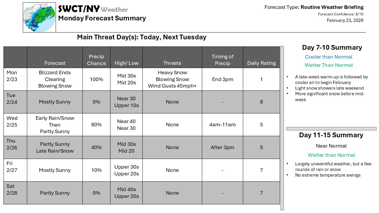
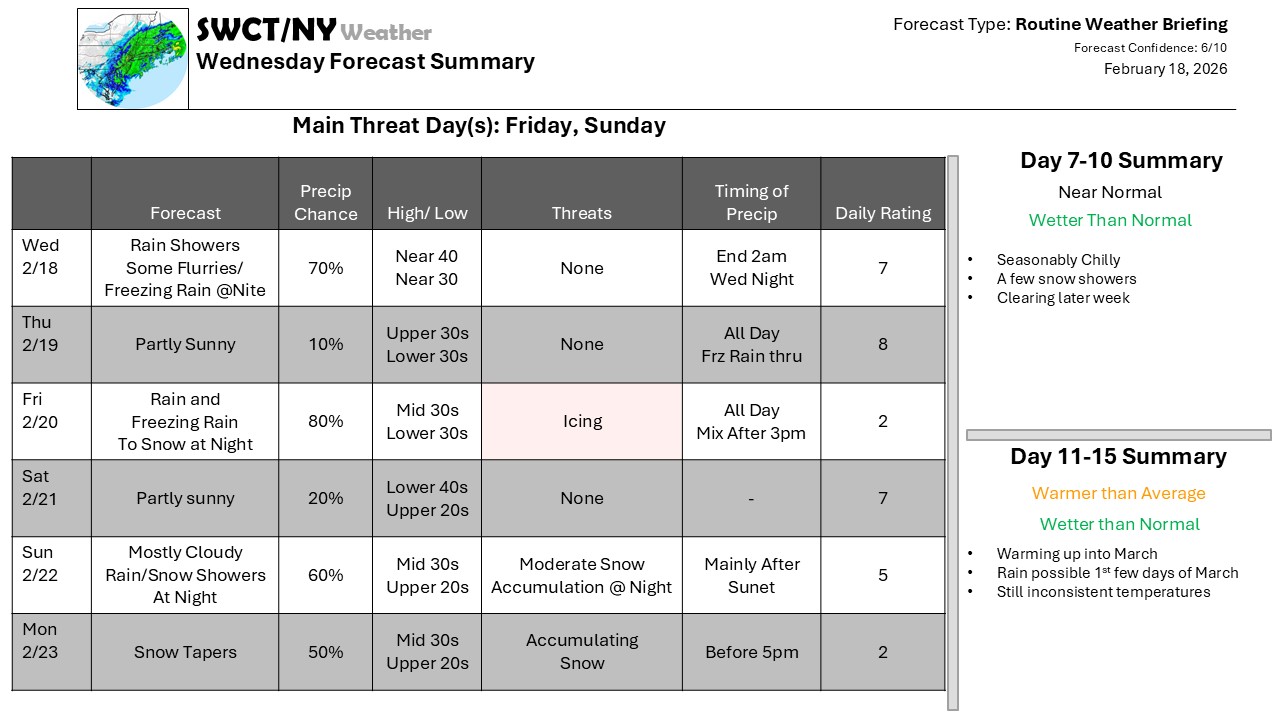
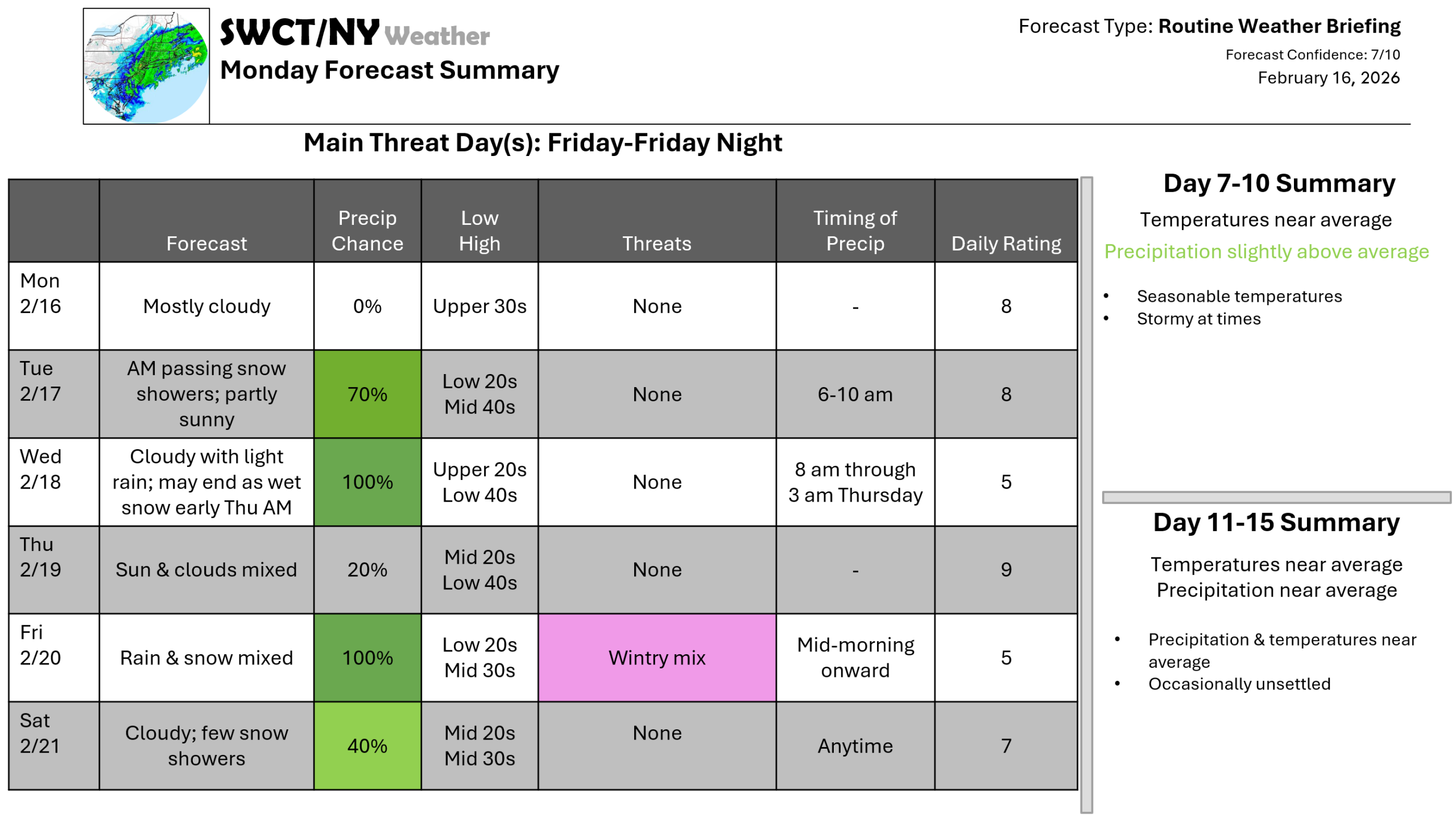
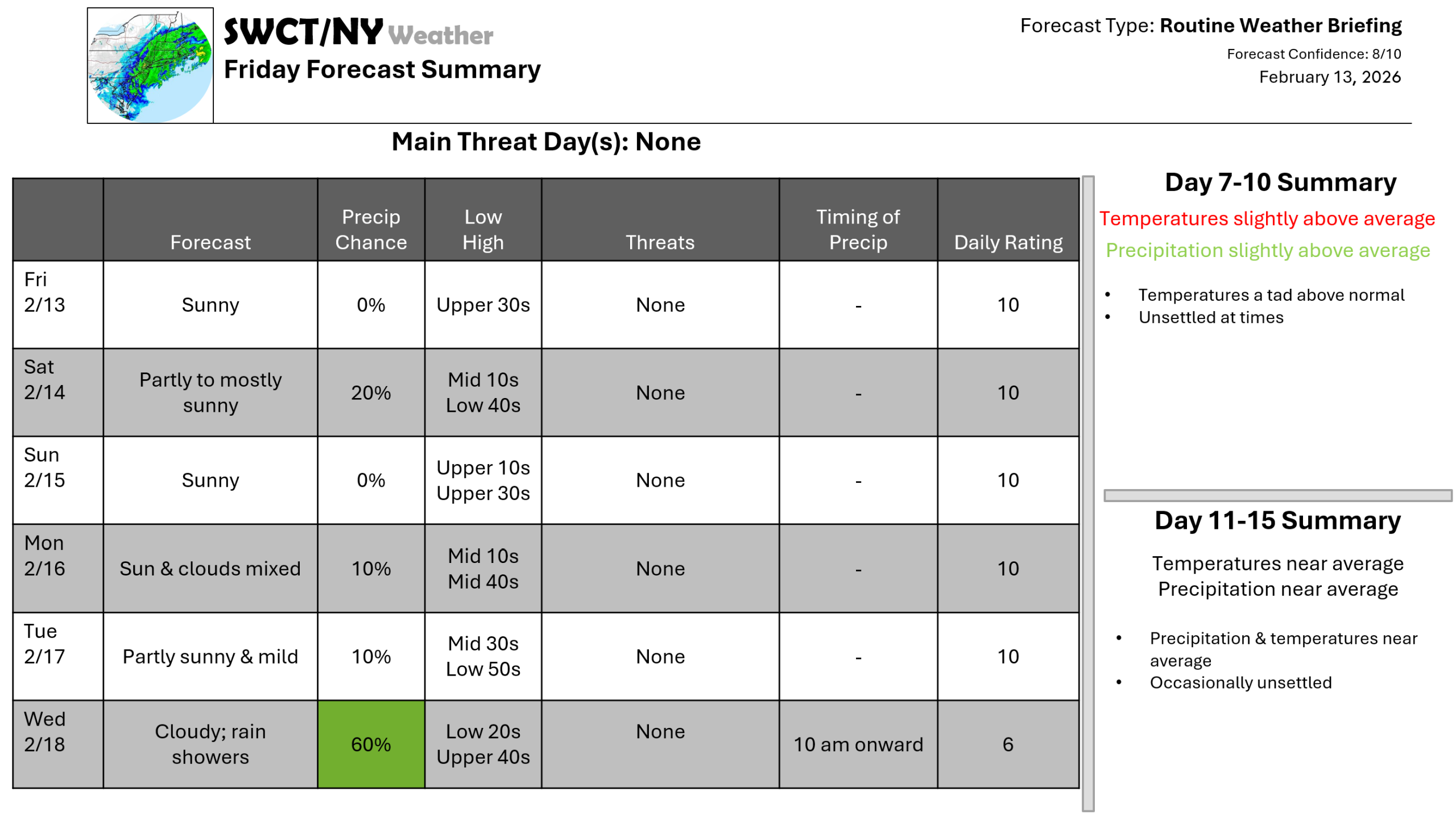
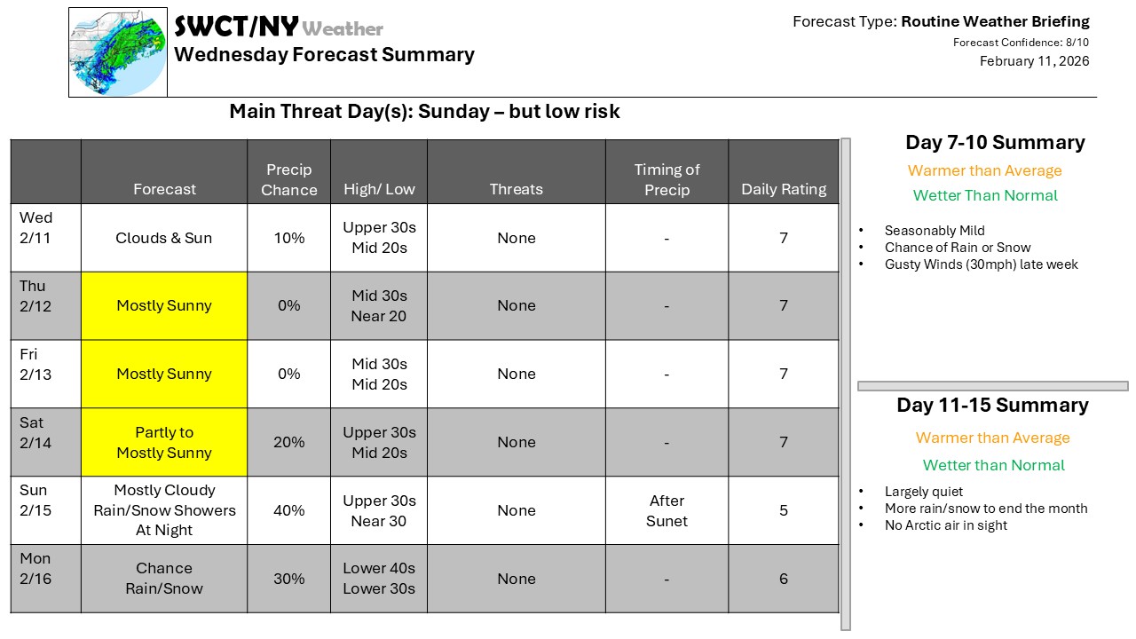
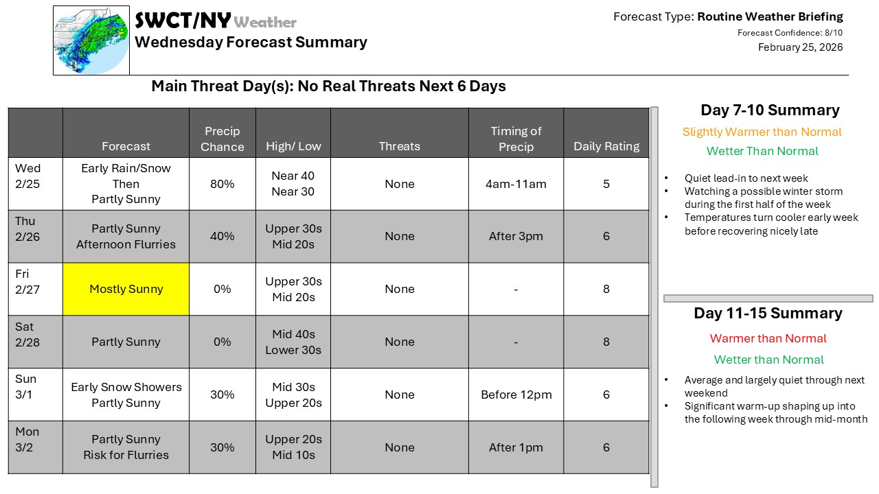
A series of weak weather systems will affect the Northeast over the next few days, but none will be particularly impactful, producing a few snow showers or flurries. Quiet weather will allow for some melting, but not too rapid; rapid enough to be noticeable, but slow enough to minimize any flooding concerns. We will have to watch for edge-ice, though – on the sides of roadways, driveways, sidewalks and the like in the morning hours as the melted snow refreezes at night.

There is a shot of colder air to start next week, but we’re generally into a much milder weather pattern – this week, and early next, snow is the main precipitation, but it’s looking more likely to be rain beyond that.

Check out the new swctweather.com – make sure to update your password so you can still login as we complete the transition process.

Premium Weather Update February 23, 2026

After what was in some areas an historic blizzard, the Nor’easter has pulled away from New England, and quieter weather settles in now. There is a quick-moving trough that will clip across the region Tuesday Night, bringing a few hours of light snow – a quick accumulation of an inch or so is possible, with the chance for some rain to mix in by midday Wednesday before the snow ends. But no sooner does the snow pick up, it ends and we dry out before another quick system brings some snow or rain later Thursday.

Warmer air follows for Friday and Saturday; February ends on a warm note before March begins on a cooler note; we’ll be watching for another storm to follow with the cold air for potential accumulating snow.

We have completed the incorporation of SWCT/NY Weather into National Weather Forecasting, Inc. All user accounts are now active on the new website, but you may have to change your password. We’ll be reaching out with special renewal offers out on a rolling schedule based on subscription renewal dates, but for now, you will be able to access the products on the website even if your subscription lapses.

-Phil Spevak

Premium Weather Update February 20, 2026

Good afternoon! A cold rain stays with us through this evening tapering to a few showers as our storm center passes by just south of Long Island. A passing snow shower can’t be ruled out through early tomorrow morning as some additional energy moves through from our northwest. Our storm for Sunday into Monday has trended closer to the region over the past 24 hours increasing the potential for a plowable 6″+ & gusty winds. There is still some uncertainty in this part of the forecast & will be monitored over the next day. The remainder of next week features seasonable temperatures with varying cloud cover as well as the risk of some rain showers Thursday as a frontal system moves through from the Great Lakes.

-Joe Sciacca

Premium Weather Update February 18, 2026

A very active weather pattern continues over the next few weeks with some type of weather system affecting the region every few days. The next few bring some winter weather thanks to a warm front sitting off to our south – some freezing rain will be possible with light icing on Friday before some accumulating snow on the back side of that wave and then again with the next Sunday Night. At this point, it still looks like this will not be a major snowstorm, but it certainly could be a significant accumulation.

Beyond that, the rate may slow to every 3 days, but the active pattern continues

-Phil Spevak

Premium Weather Update February 16, 2026

Good afternoon! A rather unsettled week is ahead as several systems move through from the Great Lakes offering us a mix of rain & snow. A more robust system moves through the region Wednesday morning through the predawn hours Thursday offering rain showers that may end as wet snow Thursday morning as colder air moves in from our north. This system moves along a warm front that will reside across the mid-Atlantic. By Friday into Saturday yet another storm system takes aim at us from our west offering a mix of rain & snow as of now.

-Joe Sciacca

Premium Weather Update February 13, 2026

Good afternoon! Through the weekend we’ll see a partly to mostly sunny sky with seasonable temperatures & light winds as surface high pressure is in control across the region. A passing flurry can’t be ruled out early tomorrow morning as some energy moves out of the eastern Great Lakes. Clouds increase Sunday night as our storm system passes by well to our south & some energy passes by to our north. Next week features more clouds than sun with the pattern becoming more active by mid week as weak systems move out of the Great Lakes as well as a nice thaw.

-Joe Sciacca

Premium Weather Update February 11, 2026

Quiet weather prevails through the week as we watch a system developing over the Southeast late-week and heading through the Mid-Atlantic on Sunday; this will have minimal northward reach, though it may be helped by an upper-level low tracking to our north, which will draw up enough moisture for at least a few rain or snow showers. The impact at this point looks minimal, and another system into next week looks the same.

Most days will feature temperatures at or above freezing through the rest of the month, which with minimal new snow coming into the system, will slowly erode the existing snowpack at a slow rate.

-Phil Spevak

Premium Weather Update February 9, 2026

Good afternoon! Through the weekend no big storms are expected as the pattern is fast moving across this part of the world. Surface high pressure keeps us settled through late tomorrow afternoon. A weak storm system & warm front moving out of the Great Lakes tomorrow night offers us light sleet & snow which last through the predawn hours Wednesday. Up to a coating of snow & sleet is forecasted. Temperatures moderate to near normal for mid week onward. There is the potential for a storm system to impact the region by Sunday into Monday.

-Joe Sciacca

Premium Weather Update February 6, 2026

Good afternoon! No big storms are in sight for at least the next week as the pattern remains fast moving across this part of the world. Temperatures remain a tad below normal this afternoon with a more robust shot of cold air by tomorrow afternoon arriving from central & northern Canada as part of the Polar Vortex moves by overhead and some energy moves through from the eastern Great Lakes offering light snow late this evening through tomorrow late afternoon. The bulk of snow moves overnight with 1-2″ forecasted. Dangerous windchills of -15 to -25 are expected tomorrow night & Sunday night. Seasonable temperatures are expected by mid next week as a pattern change occurs across North America. A weak storm system moving through from the Great Lakes Wednesday looks to offer a mix of rain & snow showers.

-Joe Sciacca

Premium Weather Update February 4, 2026

High pressure is in control across the Northeast; it hasn’t shaken all of the clouds and it certainly hasn’t allowed for too much warming, but it’s set up some decent weather. A new Arctic cold front has begun digging into the Plains – but we’re seeing its true Arctic nature yet; in fact just as quickly as cold air drops in across the Northern Plains, it begins retreating as warm air builds northward. The deepening low will move eastward and it crosses the Great Lakes, a tightening wind field and the Arctic air will expand behind it, and as it gets here by Friday, we’ll see both impacts – cold and wind, which will mean biting wind chills as temperatures fall on Saturday. The storm sets up a bit of a block for the Eastern US, so that warm-up in the Plains will get stopped in its tracks.

Snow won’t be a major piece of this storm; in fact, most of the accumulating snow likely falls within a few hours early Saturday right along the front with lighter snow showers lingering from there. There will be a slow warmup into the middle of next week, but it will be cut short as another cold front moves across the Northeast Wednesday.

-Phil Spevak